
This post is also available in:
 Hrvatski (Croatian)
10/1/2021 (Sunday)
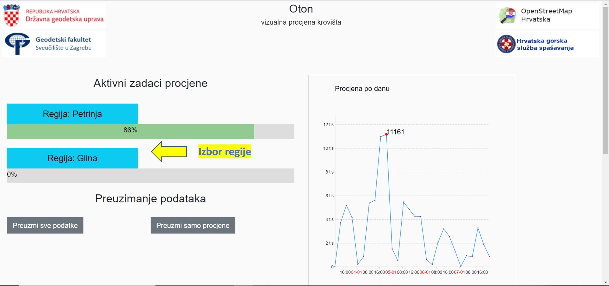
The Croatian OSM community has prepared a statistical overview and a new task for the Oton application. Users can now select the “region” for which they want to visually assess the roof condition. For the town of Petrinja, 86% of the roofing has already been assessed, while for Glina the process is just beginning. https://oton.osm-hr.org/
9/1/2021 (Saturday)
The development of the DOF for Glina has been completed and it is available on the server of the Faculty of Geodesy: http://baze.geof.hr/potres2020/20210107_Glina/

8/1/2021 (Friday)
The Civil Protection Headquarters in charge of eliminating the consequences of the earthquake in the Sisak-Moslavina, Zagreb and Karlovac Counties has published a new informative website: https://potresinfo.gov.hr/.
The set of activities jointly implemented by the State Geodetic Administration of the Republic of Croatia and the Faculty of Geodesy at the University of Zagreb in cooperation with the Croatian Mountain Rescue Service and the Croatian OpenStreetMap community is described on the website:
https://potresinfo.gov.hr/drzavna-geodetska-uprava/120.
The central news of Croatian Television showed an article about the interactive digital map “Potres 2020”, recorded at the Faculty of Geodesy on the January 4, 2021. The complete announcement with a link to the video can be found on the pages of Croatian Television:
https://vijesti.hrt.hr/698018/potres-2020-aplikacija-koja-zivot-znaci.
7/1/2021 (Thursday)
A coordination meeting was held at the State Geodetic Administration. It was concluded that the Croatian Mountain Rescue Service continues with targeted surveying of the terrain in cooperation with the Faculty of Geodesy at the University of Zagreb which coordinates the production of digital orthophotos. The official portal for all services in the field is being prepared and will be united in the “State Cloud”. The State Geodetic Administration of the Republic of Croatia makes all necessary data available in digital form.
The Croatian Mountain Rescue Service recorded the area of Glina and Majske Poljane. The images were submitted to the Faculty of Geodesy at the University of Zagreb which produces digital orthophotos.
A preliminary map of the visual assessment of the roof condition created using the Oton application has been published.
Oton 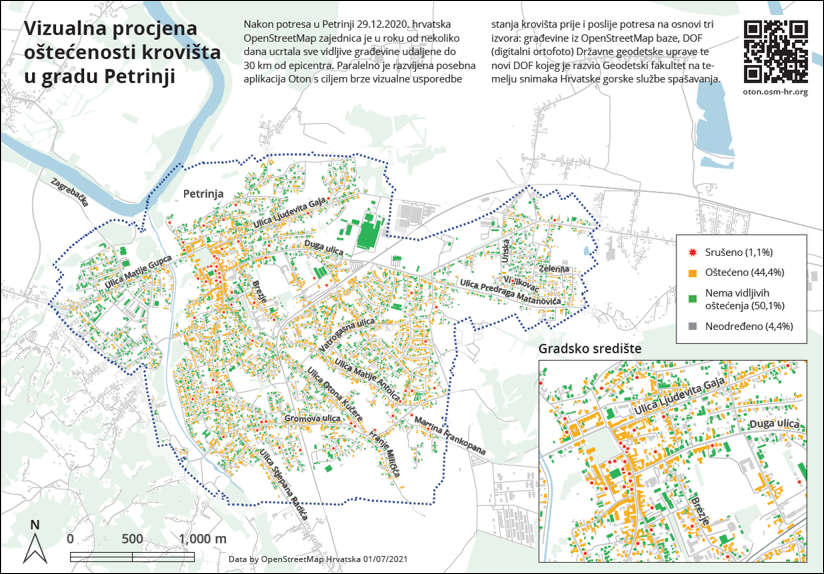
6/1/2021 (Wednesday)
Digital orthophoto, available on the servers of the Faculty of Geodesy, is created for the following areas:
Sisak: http://baze.geof.hr/potres2020/20210103_Sisak/
Petrinja: http://baze.geof.hr/potres2020/20201230_tr/
Mošćenica: http://baze.geof.hr/potres2020/20210105_Moscenica/
Drenčina: http://baze.geof.hr/potres2020/20210102_Drencina/
5/1/2021 (Tuesday)
The Croatian Mountain Rescue Service has submitted new images from the Sisak area. A digital orthophoto is made from aerial photographs and prepared for publication on the servers of the Faculty of Geodesy.
The visual assessment of the roof condition in the town of Petrinja is continued using the Oton application.
4/1/2021 (Monday)
Images for the Sisak area recorded by unmanned aerial vehicles of the Croatian Mountain Rescue Service were taken over. Based on the images, a new digital orthophoto of the imaged area (the centre of Sisak) will be made.
Dean and Vice Dean of the Faculty of Geodesy, Director General of the State Geodetic Administration, and a representative of the Croatian OpenStreetMap community participated in the constituent session of the Civil Protection Headquarters in charge of removing the consequences of the devastating earthquake, chaired by Deputy Prime Minister Tomo Medved. All members of the Civil Protection Headquarters were shown the possibilities of the public portal https://potres.2020.openit.hr, and a new digital orthophoto for the city of Petrinja. It was concluded that the data of all competent authorities should be unambiguously georeferenced and shared on the future official portal.
3/1/2021 (Sunday)
Get involved in the visual assessment of the roof condition in the Petrinja area: https://oton.osm-hr.org/
Short instructions (more details in the attachment Oton.pdf):
- Regardless of the possible small offset with the blue dashed line of the bordered polygon, click on the appropriate button above DOF 2018 (left) and DOF 2021 (right),
- If the error is too big, click on “Error”,
- You will get the next polygon and continue.
2/1/2021 (Saturday)
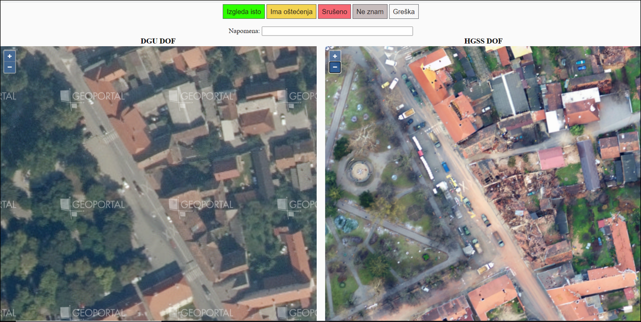
An application which allows concurrent comparison of identical parts of the city of Petrinja on the DOF 2018/19 and the new DOF recorded after the earthquake in two adjacent frames was created.
The development of the DOF for the city of Petrinja has been completed. The consent of the State Geodetic Administration of the Republic of Croatia for the use of data from the Register of Spatial Units for Earthquake Endangered Areas was requested and obtained: house numbers will be added to the data in OpenStreetMap.
The Croatian Mountain Rescue Service has been provided with detailed information on vectorized data of houses and access roads in OpenStreetMap – currently the most up-to-date map according to which it is possible to find remote facilities with residents who need help.
1/1/2021 (Friday)
In addition to continuing the work on image processing and filling in the OpenStreetMap, a detailed notification on the activities undertaken was submitted to all media in the Republic of Croatia as well as to the competent services that manage the crisis in the earthquake-affected area. The address of the digital interactive map https://potres2020.openit.hr/ is published on numerous portals with all relevant data.
31/12/2020 (Thursday)
Images from the town of Petrinja (20 GB) were taken from the Croatian Mountain Rescue Service. The State Geodetic Administration of the Republic of Croatia has issued all necessary permits for the use of aerial images. Individual volunteers and companies from Croatia and the diaspora started with organized and coordinated data processing with the aim of creating a new digital orthophoto (DOF). The digital interactive map https://potres2020.openit.hr/ receives a telegram channel on which all volunteers who were already in dispose of the data on the resident needs in the field are included in the work. Moderator roles are assigned, and communication channels are systematically established between citizens, volunteers, and relevant services.
30/12/2020 (Wednesday)
After the morning damage check in classrooms, laboratories and offices, a work plan was made to help earthquake endangered areas, of which all employees and students of the Faculty of Geodesy were informed. The call with a description of three priority tasks was published on the Faculty’s official website (https://www.geof.unizg.hr/novosti/geofunizg-hr-osm-platforma-potres2020/).
Volunteers, with expert knowledge in image processing and editing OpenStreetMap contacted potres2020@geof.unizg.hr, were deployed and started working on the project of supplementing OSM with vector data.
In cooperation with the Croatian OpenStreetMap community and OpenIT d.o.o. ushahidi-platform has been established – a digital interactive map with standardized categories for easy entry of offers and needs for help in the earthquake-affected area: https://potres2020.openit.hr/
29/12/2020 (Tuesday)
At 12:19 pm, another strong earthquake measuring 6.2 on the Richter scale shook the Sisak-Moslavina County and the wider Zagreb area. Additional damage occurred in the building of the Faculty of Geodesy at the University of Zagreb.
Share via: